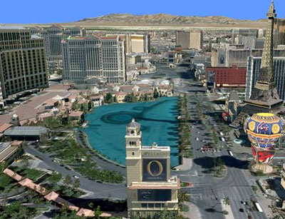
Our planet has become a lot smaller since the advent of online mapping phenomenon. Google, Yahoo, Mapquest and Microsoft have all been working in this field for quite some time now. Recently, Microsoft team released new ‘Live Search Maps’ and Virtual Earth 3D. These are improved additions to Microsoft’s mapping service. Some of the distinct features are:
- Export digital maps to portable Navigation and GPS Devices: In the new version of the digital maps, Microsoft has added an extra feature that will greatly enhance navigation aid to the users with complete driving instructions for a specific location. These maps can now be downloaded to portable navigation and GPS (Global Positioning System) devices. It is achieved by including support for exporting Collections to KML, GPX and GeoRSS systems.
- Bird-Eye’s Imagery simplified: The Virtual 3D Earth has now been embedded with labels for Bird’s Eye View imagery, thus making it very convenient to switch between aerial and regular map view of selected location.
- Improved 3D modeling: The 3D modeler has been greatly improved, as a user can now create his own buildings and structures with high resolution textures. The enhanced 3DVIA editor will include lighting for contributed models and creation of preview thumbnails when a model is saved.
- Inclusion of Google MyMap links: With the use of ‘mapurl=’ parameter, Microsoft has enabled the viewing of a KML file hosted on the web without the need of import function. This feature also facilitates improved KML support to handlecustom icons, network links and Google MyMap links.

For complete information you can also visit: http://virtualearth.spaces.live.com/blog/cns!2BBC66E99FDCDB98!14129.entry


